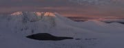
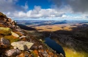
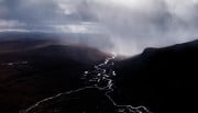
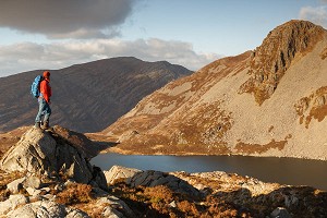
The Cairngorms and NE Scotland: 10 Must-Do Hill Days

© Robert Durran

The Cairngorms attract enthusiasts like few other mountain ranges in the country. The high tops are surrounded by upland terrain of a similar character that stretches west across the Monadh Liath, south to Perthshire and the Angus Glens and eastwards in a series of diminishing hills towards the North Sea.

Northeast Scotland - home of wide open spaces and big skies  © Gordon Watt
Northeast Scotland - home of wide open spaces and big skies
© Gordon Watt

This is a land of extensive high plateaux, big, open skies and deeply incised valleys, whose connections provided ancient routes through these mountains. Meanwhile, the lower-lying glens contain the largest surviving remnants of the Caledonian pine forest.

Here are some personal highlights of the ranges covered in the SMC's new guidebook The Cairngorms & North-East Scotland, written by authors Iain Young, Anne Butler and Heather Morning.

Big mountain days – Whitewell to Braeriach and The Devil's Point, back via the Làirig Ghru

Starting in the pine forests of Rothiemurchus and taking in a round of the Munros bordering An Garbh Choire, home to the most enduring snow in Scotland, then returning through the iconic Làirig Ghru mountain pass, this is one of the great days out in the Cairngorms.

Cairn Toul, the Devil's Point and the Lairig Ghru from Ben Macdui  © Robert Durran
Cairn Toul, the Devil's Point and the Lairig Ghru from Ben Macdui
© Robert Durran

At the col between Sròn na Làirige and Braeriach lie several pieces of aircraft wreckage, including the remains of an Airspeed Oxford, which crashed after flying into a downdraft during a training flight. Below the summit of Braeriach springs the Wells of Dee, at 1220m the highest river source in Britain, from where the infant River Dee runs over the crags of Garbh Choire Dhàidh.

Pleasant, grassy tundra-like terrain leads across Càrn na Criche and follows the cliff edge above Garbh Choire Mòr, giving way to boulder field before the summit of Sgor an Lochain Uaine (The Angel's Peak). In winter, huge cornices develop along the edge of the corrie rims, from where the ground falls steeply for 700m into the Làirig Ghru. Westwards, grassy slopes lead to the Mòine Mhòr, an area with an overwhelming sense of remoteness. The last Munro on the round is the Devil's Point, a Victorian translation of Bod an Deamhain – the penis of the devil or demon. From here you can enjoy spectacular views down the steep broken cliffs into Glen Dee and Glen Geusachan before the long, tiring journey back through the Làirig Ghru.

Stunning views from lesser-known hills – Kennapole Hill

Kennapole is a wee gem of a hill with a surprising view. Forest tracks lead up to the south-east ridge, across a 'March Dyke' and on to the summit through an open forest of granny pines, silver birch and juniper, which is part of the Inshriach National Nature Reserve. If you're lucky, you may spot a capercaillie! From the Duchess of Bedford's cairn at the summit is a magnificent view north-east across Loch an Eilein, and just below is Creag a' Chait (Cats' Den), referred to in the stone inscription on the cairn. Presumably this was the haunt of wildcats in days gone by, and if the reintroduction project at the nearby Highland Wildlife Park is successful, this area may well be home to future generations of the rare 'Highland Tiger'.

The high plateaux are a unique and very special feature of the Cairngorms  © Robert Durran
The high plateaux are a unique and very special feature of the Cairngorms
© Robert Durran

Scotland's Arctic – the high plateaux

The high plateaux of the Cairngorms are a unique environment in these isles. Much of it provides carefree wandering in summer across screes, mosses, grasslands and boulderfields. In winter conditions, however, it can be everything from an exhilarating playground for travel on foot or ski, to a place where it is impossible to make any progress whatsoever against the wind and snow.

The Angus Glens – Hunt Hill

With a picturesque approach past the ruined Invermark Castle and along the side of Loch Lee into a craggy corrie, and with views of a couple of fine waterfalls, an ascent of this little-known peak hidden away in the upper reaches of Glen Lee makes for a varied day out. Past Johnny Gordon's bothy, the escarpment formed by Bruntwood Craig and Earn Craig is followed before veering west to the summit of Hunt Hill. Care is required on the steep, rocky descent to the Falls of Damff, from where the lovely footpath down past the even finer Falls of Unich offers the quickest return. Taking in Craig Maskeldie offers a longer round.

There's also plenty of drama away from the high tops of the central Cairngorms  © Iain Young
There's also plenty of drama away from the high tops of the central Cairngorms
© Iain Young

Unique tors sprinkled across the granite summits – Bennachie

As the high land gradually dwindles eastwards towards the North Sea, Aberdeenshire's farmland is dominated by a last mountain outlier at Bennachie.

Mither Tap from the summit  © Iain Young
Mither Tap from the summit
© Iain Young

A complex hill, the tops of most interest are the prominent tor of the Bennachie - Mither Tap, the highest summit at Bennachie - Oxen Craig and the outlying Millstone Hill. Easy access, plentiful parking and well-graded paths mean these hills are popular with families, hillwalkers, trail runners and mountain bikers alike. A highlight is the summit hill fort on the Mither Tap, whose walls are over 1200 years old. Long thought to be Iron Age, recent research has revealed a long period of Pictish use in the 7th and 8th centuries CE.

Mountain Passes – The Làirig an Laoigh

The Làirig Ghru is rightly one of the most famous mountain passes in Scotland, but its gentler companion, The Làirig an Laoigh (Pass of the Calves), is just as good. Although longer and more indirect, the going is less rough, and in the 18th century, cattle were driven through here to Braemar and then onwards to the Falkirk Tryst. The 30km route from Glenmore Lodge to the Linn of Dee reaches an altitude of 792m and involves a major river crossing of the River Avon. Early highlights include An Lochan Uaine (The Green Lochan) and expanding views over Abernethy Forest and the rolling hills of Morayshire. Views of Bynack More and the tors of the Barns of Bynack then emerge before you reach the Fords of Avon Refuge. The summit of the pass lies beyond the Fords of Avon and, once over this, the vista opens out and extends south down the length of Glen Derry, whose lower reaches are a marvel of natural forest regeneration thanks to efforts by the National Trust for Scotland to reduce the deer population.

Lesser known approaches – Beinn Avon from Tomintoul

The most difficult of the main Cairngorm summits to reach and therefore the least visited, Ben Avon lacks the great cliff girt corries of the other high mountains, but the landscape of its extensive, lonely plateau, with its scattered granite tors, is rare in a global sense, and the quietude adds greatly to its charm.

Most often climbed from Deeside, the approach from Tomintoul is a fantastic alternative, particularly in autumn. Going this way, you pass the grand lodge at Inchrory and the lime-rich crags of Craig Builg, which nurture richer vegetation than usual. On the plateau lie the tors of Meall Gaineimh and Clach Bhan, and after East and West Meur Gorm Craig, the wide-open spaces to the summit are a delight. The summit tor, Ben Avon - Leabaidh an Daimh Bhuidhe, requires a short scramble in summer and some trickier climbing in winter.

Highland Perthshire – Carn a' Chlamain and Glen Tilt

Carn a' Chlamain is a secluded Munro in a grand location high up Glen Tilt.

Carn a' Chlamain and the Tarf Hotel (not a hotel)  © Mike Dixon
Carn a' Chlamain and the Tarf Hotel (not a hotel)
© Mike Dixon

The long approach is made easy by cycling from Old Bridge of Tilt and continuing past Gilbert's Bridge into the upper reaches of this fine glen, where the long south-west ridge on the east side of the Allt Craoinidh offers the easiest option to the summit. The other takes a path zigzagging up the steep hillside soon after Forest Lodge (close to the famous location visited by James Hutton). Combining the two routes makes for an excellent circular walk. Other options include combining the hill with Beinn Mheadhonach or, like Queen Victoria, descending west and south over Sròn a' Chrò. Lovers of solitude can climb the hill from north, perhaps staying at the 'Tarf Hotel' bothy on the way.

Mountain ridges – The Stuic, Lochnagar

Approaching Lochnagar from the north is a marvellous alternative to the usual route, and going via the Stuic Buttress (Summer) (Grade-1) adds the spice of a Grade 1 summer scramble, though in winter it becomes a serious snow and ice climb. The Stuic (pronounced stooee), visible from the old Bridge of Dee at Invercauld, rises as a sharp little ridge from Coire Loch nan Eun onto the plateau. The approach to the base of the ridge through the gorgeous pine woods of Ballochbuie passes one of the loveliest waterfalls in the whole area, the Garbh Allt Falls, before picking up a fine little path into the corrie. From the top of the ridge, the rim of Coire Lochan nan Euan soon leads to the summit.

Corrour bothy under the Devil's Point  © Hamish Frost
Corrour bothy under the Devil's Point
© Hamish Frost

Bothies and shelters

Bothies are part of North-East Scotland's mountain culture, and no multi-day trip in these hills would be complete without a stay in one. Neil Reid generously contributed almost all the text about bothies for the guide, covering locations, amenities and history. From the old and famous, like Corrour, to the newest, the Red House, there are large, well-appointed bothies, tiny stone-clad shelters and even rock shelters. Most famous of these is the Shelter Stone, but there are other bivouacs on Beinn a' Bhùird and on Braeriach.


Loading Notifications...
Facebook Twitter Copy Email